Overview of the Kanto Region
Area
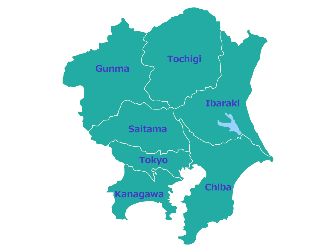
The Kanto region is located in the eastern part of Honshu, Japan’s main island, and covers about 32,000 square kilometers, accounting for roughly 9% of Japan’s total land area. It includes seven prefectures: Tokyo, Kanagawa, Chiba, Saitama, Ibaraki, Tochigi, and Gunma.
Population
The Kanto region is Japan’s most populous area, home to approximately 43 million people—about one-third of the nation’s total population. The Tokyo metropolitan area forms one of the largest urban zones in the world.
Location
The Kanto region lies between the Pacific Ocean to the east and mountain ranges to the west and north. It serves as the political, economic, and cultural center of Japan, with Tokyo as the capital.
Nature
Topography
The Kanto Plain dominates the region, forming the largest lowland area in Japan. Surrounded by mountains on three sides and the Pacific Ocean to the east, the Kanto region features a diverse landscape.
Major topographical features:
- Kanto Plain: A vast flatland extending across Tokyo, Saitama, and Chiba, supporting dense urban development and agriculture.
- Plateaus: Musashino Plateau, Shimosa Plateau, and Omiya Plateau formed by volcanic ash deposits.
- Rivers: Tone River (Japan’s second-longest river), Arakawa River, Tama River, and others that supply water and support agriculture.
Climate
The Kanto region has three climatic types due to its wide geography and varied elevation.
- Coastal Areas: Pacific Ocean Climate
The coastal areas of Chiba and Kanagawa have mild winters and humid summers, influenced by the warm Kuroshio Current. - Inland Areas: Inland Climate
Gunma, Tochigi, and Saitama have colder winters and hotter summers, with large temperature differences between day and night. Strong northwesterly winter winds can bring dry air. - Southern Islands: Subtropical Climate
The Izu Islands and Ogasawara Islands experience warm temperatures throughout the year, with coral reefs and diverse tropical vegetation.
Industries
Agriculture
Agriculture in the Kanto region is diverse and benefits from fertile plains and strong consumer demand from large urban centers.
- Upland farming and vegetable cultivation are active near major cities (peri-urban agriculture).
- Saitama and Chiba are known for vegetables such as spinach, carrots, and cabbages.
- Gunma and Tochigi produce wheat, konnyaku, and dairy products.
- Chiba is famous for peanuts, and Ibaraki for melons and lotus roots.
Industry
The Kanto region is the largest industrial center in Japan, consisting of several major industrial zones.
- Tokyo Bay Area: The Keihin Industrial Zone (Tokyo, Kawasaki, Yokohama) and the Keiyo Industrial Region (Chiba) feature steel, petrochemical, machinery, and electronics industries.
- Pacific Coast: The Kashima Coastal Industrial Zone (Ibaraki Prefecture) developed around a large-scale industrial port.
- Inland Areas: The Northern Kanto Industrial Region (Gunma, Tochigi, Saitama) produces automobiles, precision instruments, and electric appliances.
Redevelopment and Urban Projects
In addition to traditional industry, redevelopment and urban renewal are ongoing across the Kanto region.
- Makuhari New City (Chiba): A planned business district with convention facilities.
- Minato Mirai 21 (Yokohama): A waterfront urban redevelopment area.
- Saitama Shintoshin: A new urban center integrating offices, commerce, and transportation hubs.
Conclusion
The Kanto region is Japan’s core area in politics, economy, and culture. It combines fertile plains that support agriculture, advanced industries that drive the national economy, and modern cities that symbolize Japan’s development.
From the bustling metropolis of Tokyo to the rural landscapes of northern Kanto, this region reflects the balance between urban progress and traditional lifestyles. The Kanto region stands as a microcosm of Japan’s diversity and dynamism.
Comments