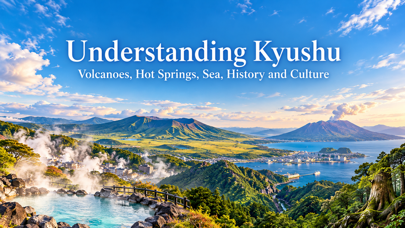
The vast caldera of Aso, steam rising from Beppu, smoke drifting from Sakurajima, the port city of Nagasaki, the gorge of Takachiho, and the forests of Yakushima.
Traveling through Kyushu, you become aware of the presence of volcanoes and the sea in many different parts of the region.
Kyushu consists of seven prefectures: Fukuoka, Saga, Nagasaki, Kumamoto, Oita, Miyazaki, and Kagoshima. In the center of the island are the volcanic areas of Aso and Kuju, while farther south lie the Kirishima mountain range and Sakurajima. The coastline is deeply indented with bays, peninsulas, and islands, and northwestern Kyushu lies relatively close to the Korean Peninsula and the Asian mainland.
This geography has shaped hot springs and agriculture, supported maritime exchange, and influenced Kyushu’s distinctive history and food culture.
Okinawa will be covered separately because of its history as the Ryukyu Kingdom and its subtropical natural environment. This article focuses on Kyushu’s seven prefectures and their surrounding islands.
- Volcanoes Have Shaped the Land of Kyushu
- In Aso, People Live Inside a Vast Caldera
- Volcanic Heat Has Shaped Kyushu’s Hot Spring Culture
- Northern Kyushu Has Long Been a Gateway to Overseas Exchange
- Arita Ware Brings Together Local Resources and Overseas Exchange
- Nagasaki Preserves the History of Overseas Exchange in Its Cityscape
- In Takachiho, Volcanic Landscapes and Japanese Mythology Overlap
- Kagoshima Developed Beside Both Volcano and Sea
- On Yakushima, the Natural Environment Changes from Coast to High Mountains
- Volcanoes, the Sea, and a Warm Climate Are Reflected in Kyushu’s Food
- Each of Kyushu’s Seven Prefectures Has Its Own Landscape and History
- Understanding Kyushu Reveals How Volcanoes and the Sea Connect Nature with History
- Sources and Further Reading
Volcanoes Have Shaped the Land of Kyushu
Volcanoes are essential to understanding the landscape of Kyushu.
Aso in Kumamoto, the Kuju Mountains in Oita, Unzen in Nagasaki, the Kirishima range on the border of Miyazaki and Kagoshima, and Sakurajima in Kagoshima are all places where the effects of volcanic activity can still be seen today.
Volcanoes have created mountains as well as enormous calderas, crater lakes, highlands, hot springs, and abundant groundwater.
Around Kagoshima Bay, Sakurajima, the Kirishima mountains, and large caldera formations are concentrated within the same broad area. Kirishima-Kinkowan National Park includes the Kirishima area, where more than 20 volcanic peaks rise together, and the Kagoshima Bay area centered on Sakurajima, each with a different volcanic landscape.
As you travel north and south through Kyushu, the character of the volcanic scenery changes.
In Aso, towns and farmland spread across the floor of an enormous caldera. In Beppu, steam rises directly from the ground. In Kagoshima, Sakurajima can be seen across the bay from the city itself.
Kyushu’s volcanoes are not simply mountains viewed from a distance. Their influence extends into the places where people live, the farmland they cultivate, the hot springs they visit, and even the food they produce.
In Aso, People Live Inside a Vast Caldera
Aso in Kumamoto Prefecture is one of the most distinctive volcanic landscapes in Kyushu.
The Aso caldera measures roughly 25 kilometers from north to south and 18 kilometers from east to west. The five peaks of Aso rise near its center, while towns, roads, railways, rice fields, and pastures spread across the caldera floor.
From viewpoints such as Daikanbo, it becomes clear just how large the caldera is and how closely human life is woven into the landscape.
The grasslands that define Aso are not untouched wilderness.
They are semi-natural grasslands that have been maintained for more than a thousand years through grazing, grass cutting, and controlled burning. Without continued human management, much of the grassland would gradually turn into scrub and forest.
Annual burning in spring and the grazing of cattle and horses have helped preserve both the open landscape and the habitats of plants and animals that depend on it.
The sight of cattle and horses grazing across Aso therefore reflects more than nature alone.
The land was formed by volcanic activity, while centuries of human activity have helped create and maintain the grassland landscape seen today.
Volcanic Heat Has Shaped Kyushu’s Hot Spring Culture
Kyushu has many famous hot spring areas.
Beppu and Yufuin in Oita, Kurokawa in Kumamoto, Unzen in Nagasaki, and Kirishima and Ibusuki in Kagoshima all offer different types of hot springs and distinctive townscapes.
In Beppu, steam rises from many parts of the city. The area is made up of eight major onsen districts with numerous hot spring sources. Alongside bathing facilities, visitors can also see intensely hot pools, mud, and steam vents at Beppu’s famous jigoku, or “hells.”
In Yufuin, the hot spring town spreads below Mount Yufu, while in Kirishima, onsen resorts lie among volcanic mountains.
Ibusuki in Kagoshima is also known for sand baths, where naturally heated sand is warmed by underground geothermal activity.
Although all of these places are described simply as “onsen,” their surroundings differ greatly depending on the local geology and volcanic landscape.
Placing Aso’s crater, Beppu’s steam, and Kirishima’s hot springs on the same map reveals how volcanic activity beneath Kyushu is connected with everyday life on the surface.
Northern Kyushu Has Long Been a Gateway to Overseas Exchange
Another important feature of Kyushu is its location close to the Asian mainland.
Fukuoka Prefecture lies relatively close to the Korean Peninsula across the sea, and people, goods, technologies, and ideas have crossed these waters since ancient times.
Dazaifu in Fukuoka Prefecture was home to an important government office responsible for administration, diplomacy, and defense in Kyushu. By the 8th century, it had developed into a major regional center and remained closely connected with overseas exchange.
Nearby Hakata also grew for centuries as a port city.
Fukuoka is now a major modern city, but looking at its position on a map makes it clear that it lies near the western edge of the Japanese archipelago, facing toward Korea and the Asian mainland.
Kyushu can therefore be understood not only as a region in southwestern Japan, but also as a place that has long looked outward across the sea toward Asia.
Arita Ware Brings Together Local Resources and Overseas Exchange
Arita in Saga Prefecture is known as the birthplace of Japanese porcelain.
In the early 17th century, potters who had come from the Korean Peninsula developed porcelain production in Arita. According to local tradition, Yi Sam-pyeong and other potters discovered high-quality porcelain stone at Izumiyama, providing an important raw material for the new industry.
The combination of local mineral resources and advanced ceramic techniques brought from the Korean Peninsula helped Arita grow into one of Japan’s leading porcelain-producing centers.
By the mid-17th century, porcelain made in Arita was being exported to Southeast Asia and Europe through the Dutch East India Company.
Overseas, Japanese porcelain was often known as “Imari,” after the port from which it was shipped, and it became highly valued among European elites.
Arita ware shows that Kyushu was both an entry point for foreign knowledge and technology and a place from which Japanese products were sent back across the sea.
The continental connections seen in Dazaifu and Hakata also survive in Saga in the form of porcelain.
Nagasaki Preserves the History of Overseas Exchange in Its Cityscape
Nagasaki on the western side of Kyushu is one of the most important places for understanding Japan’s history of overseas contact.
During the Edo period, Dejima was established in Nagasaki, and trade and the exchange of information with Europe continued through the Dutch trading post. Trade with China was also active, leaving the city with layers of Japanese, Chinese, and European cultural influence.
This history can also be seen in Nagasaki’s food culture.
Dishes and sweets such as champon and castella, now closely associated with the city, reflect influences that developed through centuries of overseas contact.
Christian history reveals another side of this exchange.
During the period when Christianity was prohibited, communities in Nagasaki and Amakusa continued to preserve their faith in secret. The Hidden Christian Sites in the Nagasaki Region, consisting of 12 component sites, were inscribed as a UNESCO World Cultural Heritage Site in 2018.
Visiting coastal settlements and islands reveals a striking contrast: ports connected the region to the outside world, while more remote communities also became places where forbidden beliefs could survive.
In Takachiho, Volcanic Landscapes and Japanese Mythology Overlap
Takachiho in northern Miyazaki Prefecture is known for its deep gorge, forests, and shrines.
Takachiho Gorge was formed as the Gokase River gradually cut through deposits created by pyroclastic flows from volcanic activity around Aso.
The same area is also closely associated with Japanese mythology.
Amano Iwato Shrine is connected with the myth in which the sun goddess Amaterasu hid inside a cave, while Takachiho Shrine and other sacred sites remain important to the region. Traditional night kagura performances also preserve stories drawn from Japanese mythology.
Farther south, Mount Takachiho-no-mine in the Kirishima range is associated with the myth of Tenson Kōrin, the descent of the heavenly grandchild to earth.
Here, mountains and gorges created by volcanic activity exist in the same landscape as mythology and religious belief.
Understanding the geology of Takachiho Gorge and then looking at the surrounding shrines and kagura traditions reveals how natural features and mythology have become intertwined in the same place.
Kagoshima Developed Beside Both Volcano and Sea
From Kagoshima City, Sakurajima rises across Kagoshima Bay.
The sight of an active volcano so close to a major city is one of the defining images of Kagoshima.
Around the bay are many other volcanic landscapes, including the Kirishima range, Mount Kaimon, and Lake Ikeda.
The region is also important for understanding Japan’s modernization.
In the 19th century, the Satsuma domain actively introduced Western technology and developed early modern industries at facilities such as the Shuseikan complex in Kagoshima. Later, industrial sites connected with iron and steel production, shipbuilding, and coal mining across Kyushu and Yamaguchi were inscribed as the UNESCO World Cultural Heritage property Sites of Japan’s Meiji Industrial Revolution.
This history also shows how knowledge and technology that entered Japan through ports such as Nagasaki contributed to modernization in places including Kagoshima.
The overlap between volcanic scenery and industrial history is another distinctive feature of the region.
On Yakushima, the Natural Environment Changes from Coast to High Mountains
Yakushima, south of Kyushu, has a natural environment very different from that of the main island.
Mountains close to 2,000 meters high rise in the center of the island, creating a dramatic difference in elevation between the coast and the interior.
As a result, the vegetation changes with altitude, from subtropical plant life near the coast to temperate forests and high-elevation plant communities.
Yakushima was inscribed as a UNESCO World Natural Heritage Site in 1993. Its major characteristics include the continuous vertical distribution of vegetation from the coast to the mountains and forests containing ancient Japanese cedar trees.
Yakusugi forests are especially famous, but the island’s significance goes far beyond its large cedar trees.
Within a relatively small area, elevation changes rapidly, and the forests and plant life change with it.
Looking up toward the mountains from the coast and then walking into the interior reveals how dramatically climate and vegetation can change with altitude, even this far south in Japan.
Volcanoes, the Sea, and a Warm Climate Are Reflected in Kyushu’s Food
Food culture changes noticeably as you travel through Kyushu.
Fukuoka is known for tonkotsu ramen and mentaiko, Saga for seafood from the Ariake Sea, and Nagasaki for champon and castella.
Kumamoto is associated with horse meat dishes and Akaushi beef from Aso, while Oita is known for seafood and chicken dishes. Livestock farming is also important in Miyazaki and Kagoshima.
In Kagoshima, sweet potatoes are closely connected with the land itself.
Much of southern Kyushu is covered by shirasu, deposits of pyroclastic material and volcanic ash created by major eruptions. These soils retain relatively little water and nutrients, while their good drainage and the region’s warm climate suit sweet potato cultivation.
Sweet potatoes can also grow in relatively nutrient-poor soils, helping them become firmly established in Kagoshima.
Today, they are eaten in many forms and are also a major ingredient in imo shochu, the region’s distinctive sweet-potato spirit.
Volcanic activity shaped the soil, the soil influenced which crops were grown, and those crops eventually became part of one of Kagoshima’s best-known drinking traditions.
Tea is also widely cultivated in southern Kyushu.
Kyushu faces several very different bodies of water.
The Genkai Sea, East China Sea, Ariake Sea, Bungo Channel, Hyuga-nada, and Kagoshima Bay all support different marine environments and seafood traditions.
Nagasaki’s cuisine reflects a history of overseas exchange, while Kagoshima’s shochu culture is connected with volcanic soils and agriculture.
Following food back to the landscape reveals connections with volcanoes, seas, climate, and the history of trade.
Each of Kyushu’s Seven Prefectures Has Its Own Landscape and History
Kyushu consists of seven prefectures, each with its own combination of volcanoes, sea, cities, and history.
| Prefecture | Main Places | What Travelers May Notice |
|---|---|---|
| Fukuoka | Fukuoka, Hakata, Dazaifu, Kitakyushu | Kyushu’s largest urban area, ancient administration and diplomacy, port history, and connections with Asia |
| Saga | Saga, Karatsu, Imari, Arita, Yoshinogari | The Ariake Sea, Arita porcelain, ceramic traditions shaped by continental exchange, castle towns, and ancient archaeological sites |
| Nagasaki | Nagasaki, Shimabara, Hirado, Goto Islands | Port history, overseas exchange, Christianity, numerous islands, and a deeply indented coastline |
| Kumamoto | Kumamoto, Aso, Amakusa, Hitoyoshi | The Aso caldera, semi-natural grasslands, Kumamoto Castle, and strong contrasts between mountains and sea |
| Oita | Beppu, Yufuin, Kuju, Kunisaki Peninsula | Hot springs, volcanoes, highlands, mountain worship, and Buddhist stone carvings |
| Miyazaki | Miyazaki, Takachiho, Nichinan, Kirishima area | Mythology, Takachiho Gorge, the Pacific coast, a warm climate, mountains, and sea |
| Kagoshima | Kagoshima, Sakurajima, Kirishima, Ibusuki, Yakushima | Active volcanoes, Kagoshima Bay, shirasu soils and sweet potatoes, Satsuma history, hot springs, and southern islands |
A journey from Fukuoka’s urban landscape to the grasslands of Aso, from Nagasaki’s port to its islands, or from Kagoshima across the sea to Yakushima reveals very different sides of Kyushu.
These differences are shaped by volcanoes, the surrounding seas, and Kyushu’s position facing outward toward Asia.
Understanding Kyushu Reveals How Volcanoes and the Sea Connect Nature with History
Kyushu contains the Aso caldera, Beppu’s hot springs, Arita porcelain, the port of Nagasaki, the mythology of Takachiho, Sakurajima, and the forests of Yakushima.
Viewed separately, they may seem like completely different destinations and traditions.
Placed together on a map, another pattern emerges.
Volcanoes created mountains and highlands and supplied groundwater and hot springs. In southern Kyushu, volcanic deposits formed the shirasu plateaus, influencing agriculture and eventually contributing to the culture of sweet potatoes and imo shochu.
In Aso, people have continued grazing and controlled burning on volcanic land for more than a thousand years, maintaining the region’s open grasslands.
The sea connected Kyushu with other parts of Japan and with countries beyond it, leaving histories of exchange in Dazaifu, Hakata, Nagasaki, and elsewhere. Ceramic techniques brought from the Korean Peninsula developed into Arita’s porcelain culture, and the finished porcelain then crossed the sea again to overseas markets.
Farther south, mythology became attached to volcanic mountains, and beyond the coast lie the forests of Yakushima.
When traveling through Kyushu, thinking about which volcano lies behind the hot spring in front of you, how the food on your table relates to the land beneath it, or what countries and regions lie beyond the port can reveal connections that are easy to miss at first.
Seen in this way, Kyushu’s natural landscapes and history begin to form one connected regional story.
Sources and Further Reading
- Japan National Tourism Organization, information on Kyushu
- Ministry of the Environment, Aso-Kuju National Park and Aso grasslands
- Ministry of the Environment, Kirishima-Kinkowan National Park
- Dazaifu City, materials on ancient Dazaifu and overseas exchange
- Arita Town and Saga Prefecture, materials on Arita ware and Izumiyama porcelain stone
- Japan National Tourism Organization, information on Nagasaki and Dejima
- UNESCO World Heritage Centre, Hidden Christian Sites in the Nagasaki Region
- UNESCO World Heritage Centre, Sites of Japan’s Meiji Industrial Revolution
- Japan National Tourism Organization, information on Takachiho
- Ministry of Agriculture, Forestry and Fisheries and Kagoshima Prefecture, materials on sweet potatoes and volcanic soils
- UNESCO World Heritage Centre, Yakushima